Every ten years, the U.S. government conducts the census, updating information on how many people live in the country, and locally how many people live in each city and town, and each neighborhood and building. Using that data, the federal, state, and local governments create new political districts, balancing the number of people in each to account for growth and shrinkage in different areas.
After voters passed Amendments Y and Z in 2018, boundaries for the congressional and legislative offices are now drawn by an independent commission. While little changed at the federal level for Denver, the state and local lines did shift, but because state legislative lines don’t cross county lines unless necessary, changes for the G.E.S. community were slight. All three neighborhoods will continue to be in House District 5 and Senate District 34, currently held by Rep. Alex Valdez and Sen. Julie Gonzales, respectively, though the shape of their districts did change.
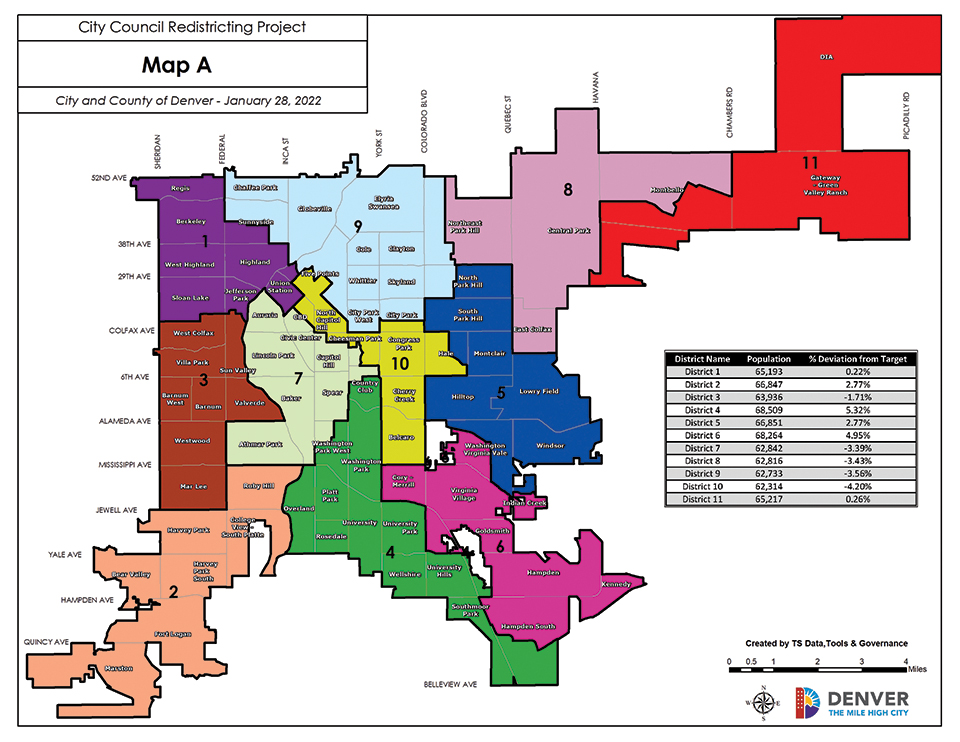
At the city level, redistricting is underway, and could include more substantive changes, especially for District 9, which includes G.E.S. The city redistricting is also at the phase where officials are seeking community input. Unlike the state’s new independent commission process, the Denver City Council draws new district lines. Councilmembers and the community submitted maps, and councilmembers were able to sponsor maps for official consideration (their own or those created by community members).
Denver Clerk and Recorder Paul Lopez’s office was responsible for creating new precincts—the smallest political boundary, which are generally smaller than a neighborhood. “I’m so proud of our team,” Lopez said in an interview, noting that his office completed their role two months early to give the council more time. Beyond that, his office isn’t involved with map creation, but as a former council member he shared some insight and recommendations. “We can’t be attached to the lines as is,” he said. “It’s not about who gets the zoo or who gets the stadium…it’s about people being represented.” He said council members should be open to lines changing.
The redistricting committee is chaired by District 1 Councilwoman Amanda P. Sandoval, who said she’s working to make the process more open and transparent, including the public’s ability to access web-based mapping software. Previously, community members had to use one of two designated computers at the City and County building, limiting access. There are also more community meetings than in previous processes, and council hired a third party facilitator to run the community meetings rather than run them themselves. Councilmembers have sponsored a total of six maps, most of which include notable changes to District 9, currently represented by Councilwoman Candi CdeBaca, though all six do keep the G.E.S. community together and in District 9.
Plan A, sponsored by Councilwoman CdeBaca, shifts the Chaffee Park and part of Sunnyside neighborhoods into 9, and shifts part of Five Points, Union Station, and the surrounding areas into
other districts.
Most other maps make other changes to the district’s southern edge: with the City Park and Union Station areas being included in some but not all. Most maps keep the current north, east, and west boundaries the same at the G.E.S boundaries, with the exception of plan F, sponsored by Councilwoman Sawyer, which would also add Chaffee Park to District 9 (though not portions of Sunnyside).
“We can’t be attached to the lines as is,” he said. “It’s not about who gets the zoo or who gets the stadium…it’s about people being represented.” He said council members should be open to lines changing.
In an interview with The G.E.S. Gazette, Councilwoman CdeBaca said she wanted to ensure marginalized communities were not “cracked, packed, or stacked” and that her map focuses on equity, transportation routes, and a variety of other factors. She also said it was important to look at how Denver’s homeless population would be impacted by shifting lines.
Four of the six maps would result in D9 being a majority white district. A and F would not.
Council passed a resolution with guiding principles for the process, including ensuring as even of a population distribution as possible, respect for communities of interest, and the like. One point was slightly more controversial though: the decision to take current council members’ home addresses into account so they would not be drawn into the same districts if they run for reelection. That differs from the state process, which does not have a similar protection, which means two sitting legislators could end up in the same district if they run again. Councilwoman CdeBaca was critical of its inclusion and said that it “made me really uncomfortable.” She said that because of that protection some districts might have to deprioritize other aspects when drawing the lines. Sandoval acknowledged that the point was more contentious, but said it was included because the majority of council members supported it. CdeBaca’s map does not take members’ current addresses into consideration, in line with her philosophy. It does place two current members in the same district if they run for reelection.
A district’s area is also important looking forward to 2023, as it can severely impact a councilmember or challenger’s election chances, including who is eligible to run. Past elections can be indicative of future races and, in 2019, CdeBaca swept the G.E.S. community with over 70% of the vote and won the majority of precincts overall, but lost the Auraria and downtown areas, which are included in District 9 in some maps but not others.
CdeBaca also expressed concerns about members drawing the boundaries for their own districts instead of using a neutral third party, referring to it as “council members in the gladiator ring.”
At the first virtual public meeting on Feb. 2, the six sponsored maps were presented, which led several community members to express frustration that no maps authored by community members were included in the formal discussion. Several council members responded that they reviewed all the community maps when creating their own. The meeting had 74 attendees at its peak according to the city, with roughly a third of those being city staff members and elected officials, based on the government emails of registrants.
The city also scheduled meetings for Feb. 9, 12, 15, and 16. If you’re interested in attending the final meeting, the information is below. Council is anticipating a final vote on March 29.
You can view all council and community created maps, as well as more information, online at denvergov.org/redistricting.
Final redistricting community meeting:
Feb. 23, 5:30-7 p.m.
Manual High School, 1700 E. 28th Ave.


Be the first to comment